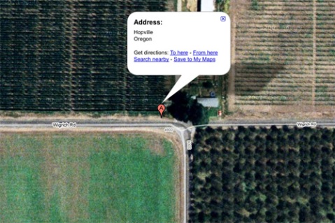
I was traveling through Oregon this weekend and decided to take a detour to the real Hopville, a rural area in Oregon. Google Maps makes it pretty clear that Hopville is a placeless place, in that there is no town or village or landmark to speak of. But Google suggests that it does have a location, which it places along a roadside by some farmhouses. The driving directions from Eugene actually ended with the grand finale: “Turn left at Wigrich Rd, then go 75 ft.”

The location of Hopville, OR according to Google Maps
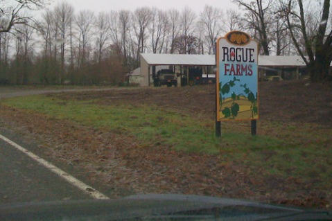
So, I had to go there, and I had to turn left at Wigrich road, and I had to go that 75 ft. How could I not? Knowing in advance that “Hopville” would amount to two Willamette Valley crop fields divided by a road, I was pleasantly surprised to discover that one of those two fields is for hops. Trellised fields were pretty common in the area, as I discovered with a little more exploration. I drove around for a while looking for a sign (literally, a sign) that I was in Hopville, hoping to snap some photos to use on Hopville.com. (Ever notice that the site has no logo? Well, one day soon, I hope that it will, and a snapshot with the word “Hopville” might’ve helped a bit.) But here’s the thing: I never found any sign of Hopville. But I did find, at the dead end of Wigrich Road (a right turn on Wigrich being the dead end direction), a very good sign:

Yep, I stumpled upon the very hop yard where the estimable Oregon brewery Rogue grows and processes its own hops.
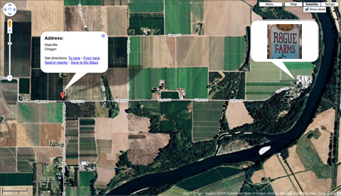
I researched this a bit online after I’d returned home. Rogue never mentions Hopville in any of their literature, so I am not sure if anyone besides Google believes the place exists. But, I’m just sayin’, here’s a wider view of the Hopville map:

Rogue brands their hops using a town a few miles northwest of this area, a town called Independence. Apparently it was once the “hop capital of the world”. From Rogue’s press release:
In May of 2008, Rogue entered into a strategic alliance with heritage hop growers the Coleman family. Rogue planted 22 acres of hops and will add 20 more this fall on the former John I. Haas Alluvial Hop Farm just south of Independence. The land, at the end of Wigrich Road, is part of a historic hop farm called the Wigrich Ranch, that in the 1920s was the largest hop yard under a single trellis in the world.
Quite a coincidence considering that I was only trying to find Hopville; apparently Rogue was too. If I didn’t have Maritime Pacific as my neighborhood brewery in Seattle, I think Rogue would have to be Hopville’s official microbrewery. Maybe I should return during growing season so I can see hops on those trellises and see if Rogue wants to sponsor their “neighborhood website”. Hmm….
Current Hopville recipe count: 1554. Hey, ain’t that a beer?
Lester Todd said
Yes Hopville has been around for quite a few years. Maybe some of us who live down here on Wells Landing Road should let Rogue know. There was a Hopville School and 1 year round store and 4 seasonal stores. We have a number of Hopville pictures and history. lestodd@aol.com
Ann Williams Thomas said
It wouldn’t do for your logo, but there is also a “locale” (per GNIS) called Hopmere north of Salem. It was a station on the Oregon Electric, and there is a sign stating “Hopmere” at the crossing.
Here’s a pic:
http://quamash.blogspot.com/2010/03/hopmere.html
Some history can be found here: http://www.salemhistory.net/transportation/electric_railway_waconda.htm
These are the coords if you want to plug them into Google Maps:
45.0498415 -122.9873189
Kathy Tonkin Pierce said
Hi Les, your right, there are a few of us Hopville kids still alive, kicking, and living on Wells Landing. To add more places to find how about Modeville, you’ll find it right next to Hopville. No place markers, but we know right where we are, even if we arn’t on a map. If Buena Vista , another small spot in the road, had become the state capitol, as it almost did, just think of the prime property we would be sitting on now! Ahh well, we have a great little community. Thanks for looking for us,
Kathy Tonkin Pierce.
Patricia McLin-Sulffridge said
I came across your web site looking for information for my family tree. My great great grandfather was Dillard McLin, who worked on the Wigrich Ranch as a seriff in 1935. I am looking for any information that will help me get to know where my fathers family came from and how long they may have been there.
Any help from anyone would be greatly appriciated.
my e-mail is: sulffridge-p-hope@hotmail.com
Thank you for the photo’s